FIRST WARN WEATHER DAY: Snowfall totals increase overnight
KANSAS CITY, Mo. (KCTV) - The morning update for this winter storm system has been absolutely challenging, to say the least. We have seen drastic snowfall accumulation changes just in the past four hours and we anticipate seeing more changes as we go throughout the day today.
THE FIRST WARN 5 WEATHER APP
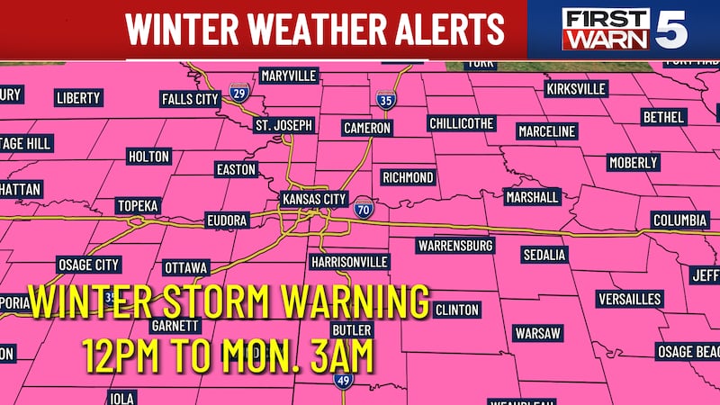
At this time, the National Weather Service has issued a Winter Storm Warning that starts at noon today and continues until 3 a.m. Monday. Blizzard-like conditions on Sunday are expected between Highway 36 to the downtown area and I-70. Gusts ranging between 35 and 40 mph mid-morning Monday through the afternoon will be common.
WATCH Saturday morning First Warn 5 Forecast:
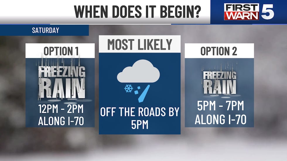
Two possible scenarios for ice timing
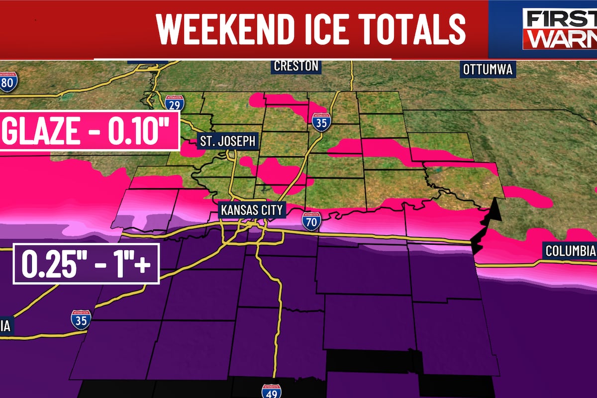
But let’s backtrack and talk about where we can begin this winter storm system. Overall, there are two significant options for the timing of the storm. Option one has the winter storm system developing isolated, freezing rain, sleet, or a winter mix to our southern counties by late this morning. Between the hours of 12 p.m. and 2 p.m., the freezing rain may lift into the metro and begin a widespread threat for freezing rain and sleet through the rest of the day until about 11 o’clock tonight. This would mean significant ice accumulations around the metro that could push closer to around half an inch to an entire inch of ice accumulation, with areas to the south pushing closer to 1 inch to 3 inches of ice accumulation.
Option two, however, says we don’t begin seeing freezing rain or winter mix in our southern counties until 3 p.m. or 4 p.m. this afternoon. After that, it builds up to I-70 as isolated to scattered threats of freezing rain and sleet between the hours of 6 p.m. and 8 p.m. This event continues overnight where we will finally see a transition to snow by early morning Sunday, between the hours of 1 a.m. and 4 a.m. In this scenario, it is more likely that the northern side of the metro may see a glaze to a tenth of an inch of ice. I-70 in downtown could be closer to around a tenth of an inch to a quarter of an inch of ice and south of the loop would range between half an inch to an inch of ice accumulation.
It is very possible that we could see one of these two outputs, a combination of both, or even an abstract transition that wasn’t necessarily picked up in any of these models. All options are still on the table until the actual winter storm system builds into the area.
ALSO READ: Kansas City begins to pretreat roads as snow plows are prepped
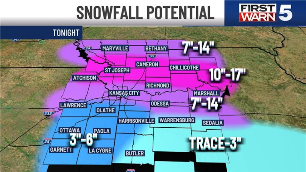
Snowfall expectations
The same statement can be said as we transition into the snow and how much snow we may see across the region. This morning, we have adjusted snowfall amounts in our forecasts that spend long-range data and short-range data. Unfortunately, the snowfall totals have not decreased, but in fact, look to increase.
Last night, Chief Meteorologist Luke Dorris brought you snowfall amounts ranging from 7 inches to 12 inches with pockets of 12 inches being possible. This morning, it is more likely that we will see closer to 8 inches being exceptionally common with pockets of 14 inches of snow in areas.
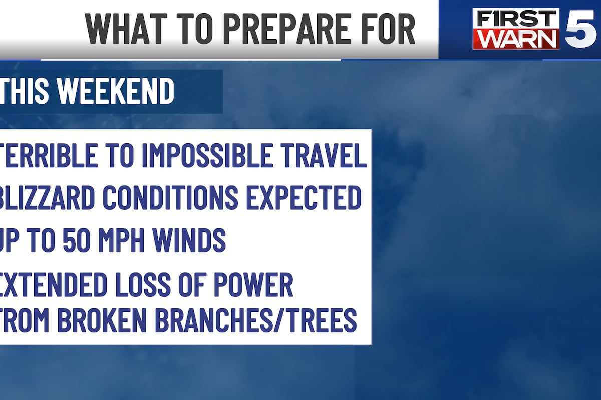
North of the metro and south of Saint Joseph could achieve snowfall totals ranging from 15 inches to 20 inches. And , at the same time that this snowfall is coming down, we are dealing with wind gusts up to 40 mph through Sunday afternoon.
ALSO READ: Car preparations, driving safely in Kansas City ahead of weekend winter storm
Temperatures
Temperatures for the winter storm system will have afternoon high temperatures in the upper 20s today dropping into the teens and low 20s tomorrow. Morning low temperatures ranging between 5° and 12° are expected.
By Monday morning, feels-like temperatures ranging from -10° to -20° will be common with high temperatures, barely in the double digits. Because of this, a First Warn Weather Day has been issued for all of Monday due to the extreme cold.
Cold conditions like this will continue throughout the work week meaning we don’t anticipate getting rid of any of the snow anytime soon.
ALSO READ: Lawerence Transit cancels on-demand services due to impending winter storm

ALSO READ: Kansas City-metro cities share plans on how winter storm will be handled
Copyright 2025 KCTV. All rights reserved.